Skip to content

Valencia, Spain’s third-largest city, has approximately 850,000 inhabitants within the municipal boundaries and around 1.6 million in its metropolitan area. Strategically located on the Mediterranean coast, it is internationally recognized for the City of Arts and Sciences, its conference and exhibition venues, its well-preserved historic center, and its urban beaches. Awarded the title of European Capital of Smart Tourism in 2022, Valencia receives over three million visitors each year.

The city has established itself as a benchmark for sustainable urban mobility, with approximately 50% of daily trips made on foot. Valencia has developed one of Spain’s most extensive cycling infrastructures, comprising 225.7 km of dedicated cycle lanes, 46.89 km of bicycle streets, and 22,958 bicycle parking spaces across the city.

This network is complemented by Valenbisi, the public bike-sharing system, which provides residents and visitors with convenient access to cycling as an everyday mode of transport. Supported by continued investment in active mobility infrastructure, the use of bicycles and micromobility vehicles has steadily increased, contributing to Valencia’s transition towards a healthier, safer and more sustainable urban transport system.

ROAD SAFETY SITUATION

In 2024, urban roads in Spain accounted for 65% (66,224) of all road traffic casualties and 28% (494) of all road fatalities. In Valencia, road traffic crashes resulted in 340 cyclist casualties and 702 personal mobility vehicle (PMV) user casualties, including one fatality in each of these two road user groups.

In response to these figures, Valencia continues to improve and expand its cycling infrastructure to provide a safer and more connected network. However, the city’s efforts extend beyond cycling facilities. Valencia adopts a holistic approach to road safety, implementing measures that also improve infrastructure for pedestrians and motorized traffic, with the objective of creating a safer, more inclusive and resilient urban transport environment for all road users.

PILOT SCOPE

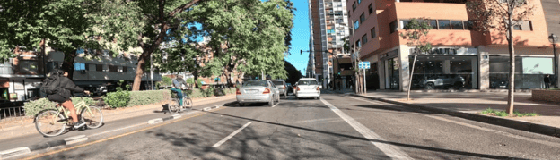
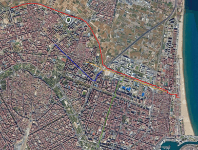
The Valencia Use Case focuses on four cycling corridors across the city, covering a total length of more than 20 km. These corridors represent a wide range of urban cycling environments and infrastructure typologies, including on-road cycle lanes along high-traffic streets as well as segregated cycle tracks located on sidewalks. Their diversity provides an ideal setting for assessing road safety challenges and evaluating solutions under different urban and traffic conditions.

Scenarios

The Valencia Use Case evaluates four different scenarios, with a particular focus on micromobility and its interaction with the urban road environment.

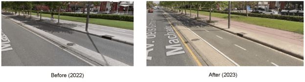
Scenario 1 assesses the relocation of a cycle track from the sidewalk to the carriageway, where it is protected from motorised traffic by a continuous raised kerb. This intervention aims to improve the safety and continuity of cycling infrastructure while reducing conflicts between cyclists and pedestrians.

SCENARIOS

Scenario 1 assesses the relocation of a cycle track from the sidewalk to the carriageway, where it is protected from motorised traffic by a continuous raised kerb. This intervention aims to improve the safety and continuity of cycling infrastructure while reducing conflicts between cyclists and pedestrians.

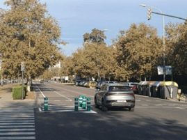
Scenario 2 evaluates the implementation of lane-specific speed limits. On roads where the general speed limit is 50 km/h, the speed limit in the traffic lane adjacent to the cycle lane is reduced to 30 km/h. This measure is intended to decrease speed differentials between motor vehicles and cyclists, thereby improving road safety for vulnerable road users.

Scenario 3 is applied across the entire study area and does not involve any physical infrastructure intervention. Instead, it analyses the impact of an increased demand for micromobility.

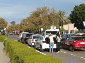
Scenario 4 focuses on Avenida de los Naranjos, one of the city’s main urban corridors. Prior to September 2024, the avenue consisted of three traffic lanes in each direction, together with a dedicated bus and taxi lane. In September 2024, the Valencia City Council implemented a major redesign of the corridor. The intervention converted the leftmost traffic lane into longitudinal on-street parking along most of the avenue, except on the section between the V-21 roundabout and Ramón Llull Street, where higher traffic volumes required the lane to remain in operation, and in the approaches to signalized intersections. In addition, a fixed speed enforcement camera was installed along one side of the avenue to improve compliance with speed limits and enhance road safety.

ACHIEVEMENTS

So far the most significant achievement in Valencia pilot study is the comprehensive safety analysis of four major cycling corridors. Factual applied the CycleRAP methodology via the Lane Patrol tool, combining structured evaluation with georeferenced image capture.

This allowed PHOEBE to assess over 40 safety features, such as infrastructure width and protective barriers, ensuring a detailed understanding of cycling infrastructure safety. Additionally, we conducted assessments of the roads adjacent to the bike lanes using the Star Rating methodology, further enhancing our insights into overall road safety in Valencia.          

OUTLOOK

Anticipated improvements stemming from the analysis of the cycling corridors include relocating existing bike lanes from sidewalks to roadways, physically separated by barriers or parking lanes where feasible. This measure aims to minimise conflicts among cyclists, pedestrians, and motor vehicles, thereby enhancing overall safety.

By prioritising ongoing efforts to analyse illegal behaviours and leveraging the insights gained to inform infrastructure improvements, Valencia can advance its goal of creating safer and more accessible cycling infrastructure. Through these concerted efforts, the PHOEBE project aims to promote active mobility and enhance the overall quality of urban life for Valencia’s residents and visitors.